Before you merge onto the interstate, the most useful thing you can know is what the road looks like right now. Route Outlook has live traffic pages for 30 metro areas: more than 6,000 DOT traffic cameras, current crashes and closures, and a plain status for every major highway, all on one page per city.
TL;DR
- 30 cities, 208 highway corridors and 6,172 traffic cameras from state and provincial DOTs
- Every highway gets a status: clear, slow or major (or closed), based on live incident reports
- Cameras are shown in driving order along each highway, and about 1,800 of them play live video
- Each crash is paired with the nearest camera, so you can see it for yourself
- Free, no app or account needed: start at routeoutlook.com/traffic
- Beyond the cameras: plan any trip with the weather timed to when you'll be there, watch your regular routes for rough weather, and get hail warnings before the storm reaches your car
Why We Built This
State transportation departments run thousands of traffic cameras and publish crash and closure reports as they happen. The information is public, but it's scattered: a different 511 website for every state, camera maps that list hundreds of cameras without saying which highway they're on, and incident lists that mix a closed ramp across town with a crash on your commute.
We wanted one page that answers the question every driver actually has: how is my highway right now? So we organized the data the way you drive it, by highway and in road order.
The Cities
The traffic pages cover these metro areas today:
- West: Seattle, Portland, Los Angeles, San Francisco Bay Area, San Diego, Sacramento, Salt Lake City, Denver
- Southwest: Phoenix, Austin
- Southeast: Atlanta, Charlotte, Raleigh–Durham
- Mid-Atlantic: Washington DC, Baltimore
- Northeast: New York City, Providence, Southern New Hampshire
- Midwest: Chicago, Minneapolis–St. Paul, Milwaukee, Kansas City, Indianapolis, Columbus, Cincinnati, Cleveland, Dayton, Toledo, Akron
- Canada: Toronto
Each city covers its main freeways: from 3 corridors in Akron to 12 in Phoenix. Chicago, the newest, has 11: the Kennedy, Dan Ryan, Edens, Eisenhower and Stevenson, I-55 to Joliet, I-290 to Schaumburg, I-80, I-57, and the Tri-State and Jane Addams Tollways. Minneapolis–St. Paul keeps I-35W and I-35E as separate corridors, because a crash on one tells you nothing about the other. More cities are on the way as we get access to each state's data.
Start With the Map
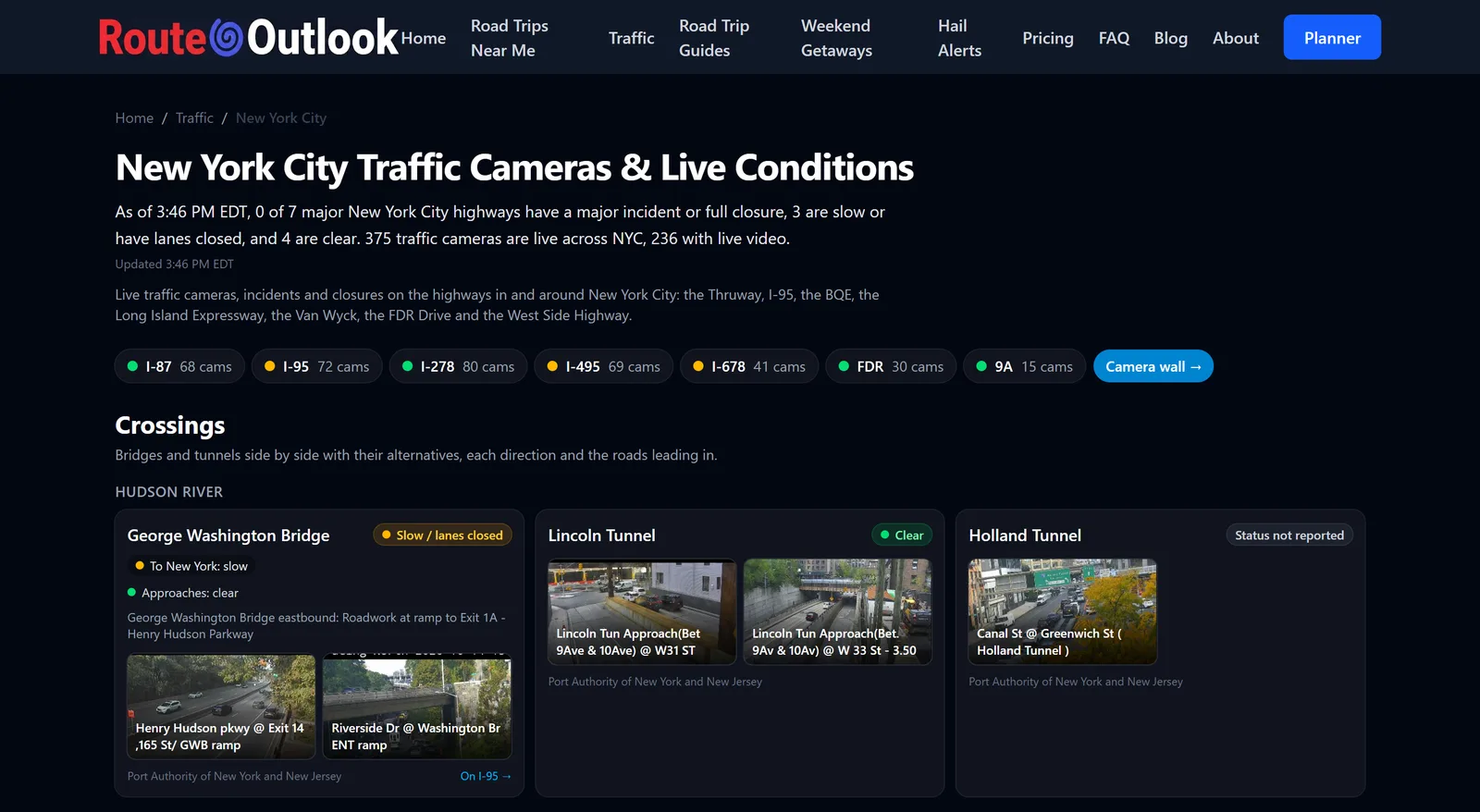
The traffic overview opens with a map of every city. Next to each city name is a row of small squares, one per highway: green for clear, amber for slow, red for a major incident or closure. A red dot on the map means that city has at least one highway in trouble right now. Above the map, a one-sentence summary tells you how many highways are clear across all cities and where the problems are.
It's a quick way to see, at a glance, whether your city is having a bad morning before you look any closer.
The City Page: Every Highway at a Glance
Click a city and you get a table of its highways. For each one you'll see:
- Status: clear, slow, major or closed
- Cameras: how many cameras cover that highway
- Incidents: crashes, disabled vehicles, debris and closures happening now
- Work zones: active road work, counted separately so a routine lane closure doesn't look like a crash
Below the table you'll find a traffic map with every corridor drawn in its status color, a list of incidents happening now, and any National Weather Service alerts in effect for the area. If a winter storm warning or a flood watch covers your city, you'll see it on the same page as the cameras.
The Highway Page: Cameras in Driving Order
This is the part we're proudest of. Open any highway (say, I-25 from Castle Pines to downtown Denver) and the cameras appear in the order you'd pass them driving that stretch, not in the random order a DOT camera list uses. You can scroll down the highway and watch conditions change mile by mile.
Many cameras also stream live video. Where a DOT provides a video stream, the camera tile offers it with a tap. In some places, like Maryland's CHART cameras around Baltimore, video is the only thing the state publishes, so you'll see a "Live video · tap to play" tile instead of a still image.
Where one camera site has several views (each leg of an intersection, or both directions of a freeway), each view is labeled, such as "looking north" or "northbound", so you know which way you're looking.
When there's a crash or closure on the highway, we match it to the nearest camera within about two miles, preferring one that faces the direction of the incident. So instead of just reading "Crash, I-435 northbound", you can look at it.
The Camera Wall
Sometimes you just want to see everything. Every city has a camera wall page (for example, Kansas City's) with up to 48 of its cameras on one screen, from across its highways. It's ideal for a quick visual sweep before a long drive across town.
How "Clear" Is Decided
A status is only useful if you can trust it, so here's exactly how it works:
- Major: at least one severe incident on that highway, like a crash blocking lanes or a full closure. If every severe incident is a road closure, the highway reads closed instead.
- Slow: a moderate crash or other incident slowing traffic, or road work closing a travel lane right now.
- Clear: nothing reported that holds up the main lanes. Minor incidents, ramp and shoulder closures, and months-long construction notices are listed as work zones but leave the highway green.
Just as important is when we don't say clear. Incident reports refresh every 10 minutes. If a state's incident feed stops updating for more than an hour, we don't show its highways as clear, because no news isn't good news when the news has stopped arriving.
The same goes for crashes we can't see. In Chicago, the public data we use reports crashes on the Tri-State and Jane Addams Tollways, but not yet on IDOT's expressways like the Kennedy or the Dan Ryan. So Chicago's pages carry a notice saying crash data is currently unavailable, and a quiet expressway there reads No closures reported, not Clear. When a crash source arrives, the notice goes away.
We also clean up after the data sources. Government feeds sometimes keep reports alive long after the road has reopened, or list cameras that are down as working. We filter those out so the page reflects the road, not the paperwork.
Where the Data Comes From
Everything on these pages comes from public transportation agencies: Caltrans, WSDOT, Oregon's TripCheck, 511NY, VDOT, Maryland's CHART, Georgia's 511GA, Ohio's OHGO, 511 Wisconsin, Minnesota's 511MN, Colorado's COtrip, Indiana's TrafficWise, KanDrive and KC Scout in Kansas City, the Illinois Department of Transportation and the Illinois Tollway through Travel Midwest, Ontario 511 and others. Every city page credits its sources under "About these cameras", and camera images are shown exactly as the agency publishes them.
To be a good neighbor to those agencies, we fetch each camera image at most once a minute, and only while someone is looking at it, however many people are viewing it.
More Than Cameras
The traffic pages show you the road right now. The rest of Route Outlook looks ahead, to the drive you're about to take and the ones you take every week.
Plan a trip with the weather on the way
Enter any trip in the Route Outlook planner and it checks the weather where you'll be when you get there, not just at your starting point. A clear morning at home doesn't help if you reach the mountain pass during the afternoon snow. The planner also suggests the safest time to leave, compares conditions across the next seven days, and shows official National Weather Service warnings along the way. On the road, Drive Mode follows your position and speaks warnings out loud so your eyes stay on the road, and one tap hands the route to Google Maps or Waze.
Watch your regular routes
Save the routes you drive often, like your commute or the weekend run to see family, and Route Outlook checks the weather along each one every four hours. When conditions along a route turn dangerous, you get an email.
Hail alerts for your car
Hail damage averages $3,000 to $5,000 a car, and it often arrives with only minutes of notice. Hail alerts watch National Weather Service storm warnings every two minutes and tell you when hail threatens the place you park, usually 15 to 30 minutes ahead: enough time to move your car into a garage. Sign-up takes an email address and a location, with no app needed.
What's free
- Free, no credit card: the traffic pages, the trip planner with Drive Mode and voice alerts, the departure-time finder, 3 trip plans a month, 3 route alerts for danger-level conditions, and hail alerts by email for destructive hail (2 inches and larger) at one location.
- Explorer ($4.99/month) and Unlimited ($9.99/month): more trip plans and route alerts (10, or unlimited), plus earlier caution-level warnings.
- Hail Alerts Pro ($1/month or $10/year): every hail size from 0.75 inch, as many locations as you like, and text messages as well as email.
See pricing for the full comparison.
How to Use It Before Your Trip
- Open routeoutlook.com/traffic and find your city.
- Check the highway you'll take. Clear? You're set.
- Amber or red? Open the highway page, look at the incident and its nearest camera, and decide whether to wait or take another route.
- Driving farther? Plan the whole trip on Route Outlook to see weather, road conditions and incidents for every hour of the drive.
- Drive the same roads every week? Save them as route alerts, and add a hail alert for where you park.
Bookmark your city's page. It's the fastest way we know to answer "how's the drive looking?" before you grab your keys.