In New York, the decision that matters is made before you can see the problem. Once you're on the ramp to the Lincoln Tunnel, you're committed. Route Outlook's crossing pages show all 12 of the city's major bridges and tunnels side by side, direction by direction, so you can choose your way across before you're stuck with it.
TL;DR
- 12 crossings: the Hudson River, East River, Long Island Sound and Verrazzano-Narrows
- Each one is rated by direction, in the words you'd use: "to New Jersey", "to Manhattan", "to Staten Island"
- Every crossing sits next to its alternatives, so you can compare the GWB, Lincoln and Holland at once
- The highways feeding each crossing are checked too, with live cameras on the spans and approaches
- Free, no account needed: start at routeoutlook.com/traffic/new-york-city
Why Crossings Get Their Own Pages
A highway gives you options. If the BQE backs up, there's usually an exit and a surface street. A bridge or tunnel doesn't: from the approach to the far side, there is one way through. The useful question isn't "is traffic bad?" but "which crossing should I take, and which way is it bad?"
Traffic maps don't answer that well. A red line across the Hudson doesn't tell you whether it's the inbound or outbound side, and you have to check three crossings separately to compare them. So we gave each crossing a page built around the choice you're actually making.
The 12 Crossings
- Hudson River: George Washington Bridge, Lincoln Tunnel, Holland Tunnel (Port Authority of New York and New Jersey)
- East River: Queens–Midtown Tunnel, Hugh L. Carey (Brooklyn–Battery) Tunnel and the Robert F. Kennedy (Triborough) Bridge (MTA Bridges and Tunnels); the Brooklyn, Williamsburg and Ed Koch Queensboro bridges (NYC DOT)
- Long Island Sound: Bronx–Whitestone Bridge, Throgs Neck Bridge (MTA Bridges and Tunnels)
- The Narrows: Verrazzano-Narrows Bridge (MTA Bridges and Tunnels)
You'll find them all on the New York City traffic page, grouped by the water they cross, and each one has its own page, such as the George Washington Bridge or the Verrazzano-Narrows Bridge.
Each Direction, in Plain Words
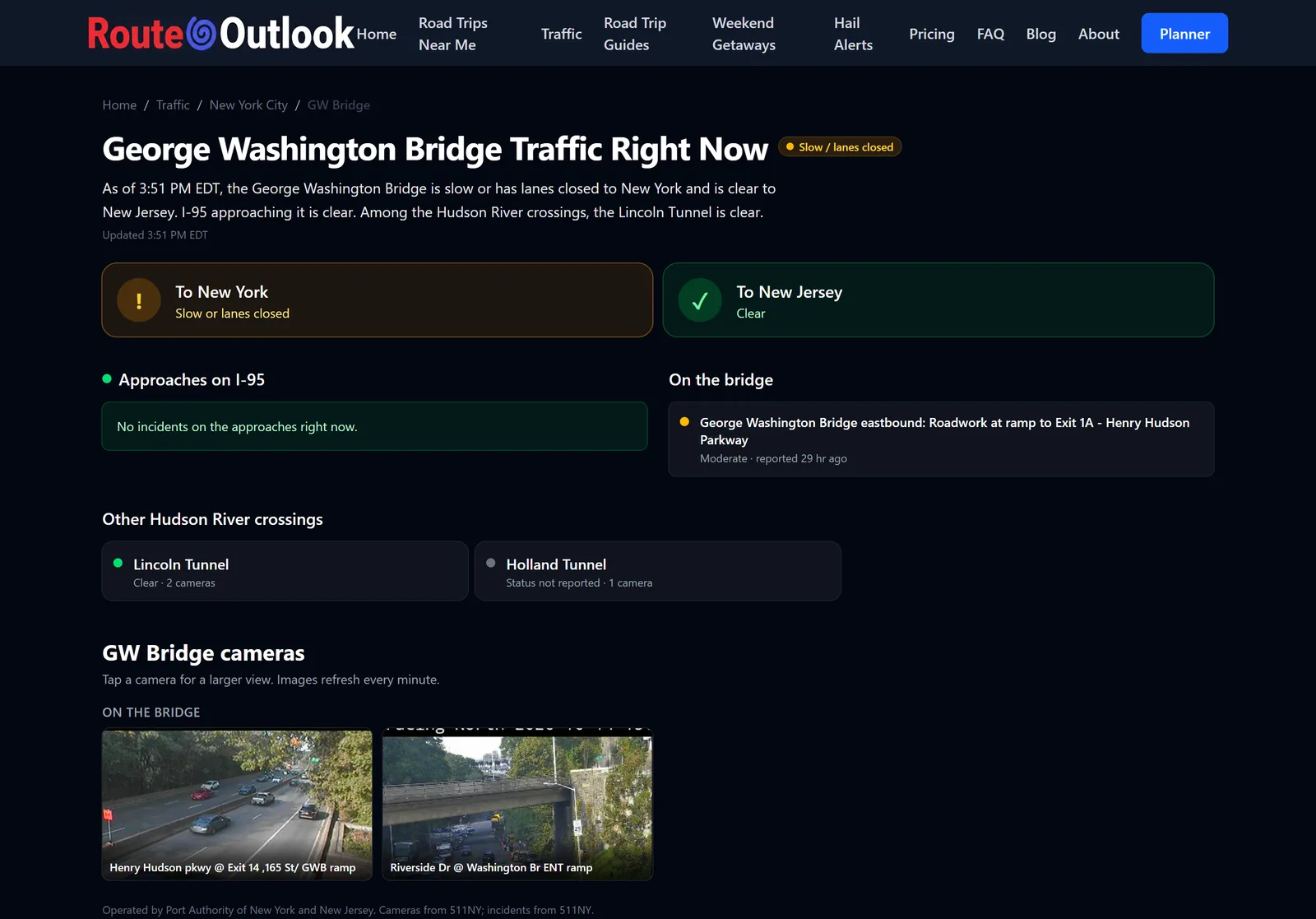
Traffic reports describe crossings by compass direction, so you have to remember that westbound over the GWB is the way to New Jersey. We translate. Each crossing page opens with one tile per direction: To New York and To New Jersey on the Hudson crossings, To Manhattan and To Brooklyn or To Queens on the East River, To Staten Island on the Verrazzano. Each tile shows its own status, because a crash on the inbound side means nothing if you're heading out.
The colors follow the same rules as every highway on Route Outlook: amber when a crash or lane closure is slowing traffic now, red for a major incident or a closure, green when nothing reported is holding up the main lanes.
Side by Side with the Alternatives
Every crossing page lists the other crossings over the same water, with their status and camera counts. On the George Washington Bridge page, the Lincoln and Holland tunnels sit right below. On the Queensboro Bridge page, the other East River crossings do. Each page also answers the question directly in words: Which Hudson River crossing is moving best right now?
The Roads Leading In
Often the crossing itself is fine and the trouble is getting to it. So for the crossings fed by a numbered highway, we watch that highway too, inside a radius around the crossing: I-95 into the George Washington Bridge, I-495 into the Queens–Midtown Tunnel, I-278 and I-87 around the RFK Bridge, I-678 into the Whitestone, I-295 and I-695 into the Throgs Neck, and I-278 on both sides of the Verrazzano. Each page shows the approaches' own status, incidents and cameras, separately from the crossing.
What the Road Signs Say
New York State's electronic message signs post travel times to the crossings, and those numbers are exactly what you're deciding between. A sign on the FDR Drive at 105th Street, for example, has read QBB: 11 / QMT: 21 / BK BR: 36: eleven minutes to the Queensboro Bridge, twenty-one to the Queens–Midtown Tunnel, thirty-six to the Brooklyn Bridge. Each crossing page lists the signs that name it, with every other crossing on the same sign, so you can compare them the way the sign intends.
Two things to know. A sign's travel time runs from where the sign stands to the crossing, so it isn't the crossing's own delay. And we only show sign times that are fresh: if 511NY's sign data hasn't updated in the last 15 minutes, we hide it rather than show you numbers from this morning.
Cameras on the Spans
The East River bridges are well covered: NYC DOT runs more than 20 cameras on and around the Brooklyn Bridge, and more than a dozen each on the Williamsburg and Queensboro bridges. 511NY cameras watch the Hudson crossings and the approaches to the tunnels and bridges, and some of them, like the one at the Queens–Midtown Tunnel, stream live video. Tap any camera for a larger view, then step through the others on the same crossing.
When We Can't Tell You
Some crossings almost never appear by name in the state's incident reports. In 30 days of reports, none named the Holland Tunnel, the Brooklyn–Battery Tunnel, the Queensboro Bridge or the Throgs Neck Bridge. For those, we don't guess: the page says Status not reported instead of showing green, and the cameras and signs still let you see for yourself. The same goes for every crossing if the state's incident feed stops updating.
More Than Crossings
If you cross the same river every day, Route Outlook can do more than show you today's traffic.
- Route alerts: save your commute and we check the weather along it every four hours, and email you when conditions turn dangerous. The free plan covers 3 routes.
- Trip planning: the Route Outlook planner checks the weather where you'll be when you get there, suggests the safest time to leave, and hands the route to Google Maps or Waze with one tap.
- Hail alerts: hail alerts watch National Weather Service storm warnings every two minutes and tell you when hail threatens where you park, usually 15 to 30 minutes ahead. Free by email for hail 2 inches and larger; Hail Alerts Pro ($1/month) covers every size and adds text messages.
See pricing for what's free and what the paid plans add.
How to Use It
- Before you leave, open the New York City traffic page and scroll to Crossings.
- Find the group you're crossing and compare the options in your direction.
- Amber or red? Open that crossing's page, check the incident, the approaches and the cameras, and look at what the signs say about the alternatives.
- Pick your crossing before you reach the approach, while you still have a choice.
Bookmark the crossing you use most. It's the quickest way to answer "which way across?" before you're committed.